Showing 179 items matching valley lake
-
 Stawell Historical Society Inc
Slide, Ian McCann, Looking Up the Valley toward Lake Bellfield, 1960's
... Looking Up the Valley toward Lake Bellfield...Clolour slide. Looking up the Valley toward Lake Bellfield...Slide Looking Up the Valley toward Lake Bellfield Clolour ...Clolour slide. Looking up the Valley toward Lake Bellfield under construction.grampians -
 Federation University Historical Collection
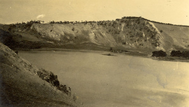
Photograph - Photograph - black and white, Mt Gambier
... valley Lake...Verso: 'The Valley Lake Mt. Gambier..., South Australia. Verso: 'The Valley Lake Mt. Gambier Chatham ...Blaclk and white photographic postcard showing a lake and mountains and Mt Gambier, South Australia.Verso: 'The Valley Lake Mt. Gambierchatham family archive, chatham, mt gambier, blue lake, valley lake -
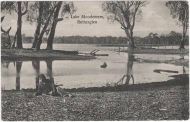 Rutherglen Historical Society
Postcard, Lake Moodemere, Rutherglen, 1900-1908
... were taken from him in the Kiewa Valley and taken to Lake... and Kate were taken from him in the Kiewa Valley and taken to Lake ...This photo is of Neddy Wheeler - Dhudhuroa man and language informant to RH Matthews. The photo was taken at Lake Moodemere. Neddy spent the latter part of his life here, especially after his Wife Charlotte and children Thomas, Harry, Dolly and Kate were taken from him in the Kiewa Valley and taken to Lake Tyers.The Aboriginal Protection Board would provide travel passes for him to visit his Country. He died in April 1908Black and white photograph, printed on postcard, showing view of Lake Moodemere, with a man wearing a jacket and hat, reclining on the bank in the foreground.Printed at top of photo: "Lake Moodemere, Rutherglen"lake moodemere, neddy wheeler, dhudhuroa, charlotte wheeler, thomas wheeler, harry wheeler, dolly wheeler, kate wheeler, kiewa valley, lake tyres, aboriginal protection board -
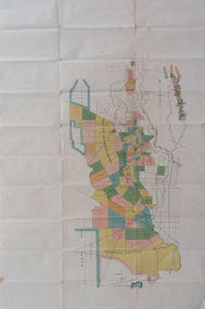 Federation University Historical Collection
Plan, Berry Bank Estates
... of the Squire Family berry bank estates mining happy valley lake rosine ...This plan is associated with former Ballarat School of Mines Student Richard Squire (1875-1876). Gift of the Squire FamilyPlan of Berry Bank Estates. Coloured plan on cream paperberry bank estates, mining, happy valley, lake rosine estates, strathvean estates proprietary, w. luplaupitfield plateau, british banner, federal mint, moller, morrow, south pitfield consols, east banner, new lallah rookh, bull dog company, mindai, j. morpoh, poliah, f. j. morrow, piggoreet east, w. m. acheson, grand trunk, field's claim south grand trunk, south grand trunk, woady yalloak creek, mount misery creek, fitzpatric's creek, illabrook creek, great western, mount bute syndicate, narringhill creek, little woady yalloak creek, piggoreet east preemptive right, southern birthday, new birthday, prince of wales, collins, brassey birthday, howarth's lead, w. price, royal birthday, a. clinton, victoria express, patons, williams fancy, hennessy, queen of the south, n, pandora proprietary gold estate, lyonbank lease, rowe's southern, rowe's extended, w. t. rowe, wallinduc company, glenfine horseshoe company, rowe's glenfine junction, wallinduc syndicate, pitfield estates, rowe's estate, southern glenfine, h. fields, christies & fields, balmoral company, glenfine united, hallett, great glenfine, rowe consuls, nicholls, london & melbourne gold mine, j. w. pascoe, christies, glenfine central, j. king, j. durston, great western extended, oswald, woadyyaloak, berringa, squire -
 Marysville & District Historical Society
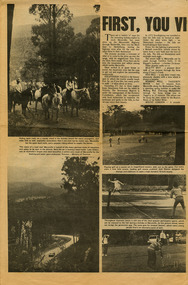
Newspaper (Item) - Newspaper article, FIRST, YOU VISIT THE FALLS, Unknown
... falls old water wheel cumberland valley lake eildon snob's creek ...A newspaper article on some of the local attractions and activities to be seen and done in and around Marysville.A newspaper article on some of the local attractions and activities to be seen and done in and around Marysville.marysville, victoria, australia, newspaper article, steavenson falls, beauty spot walk, red hill walk, wishing well, taggerty river, mount gordon, keppel's lookout, keppel falls, old water wheel, cumberland valley, lake eildon, snob's creek fish hatchery, alexandra, mansfield, jamieson, wood's point, warburton, healesville -
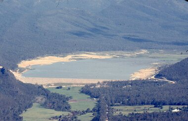 Stawell Historical Society Inc
Slide, Ian McCann, Long shot Lake Bellfield being filled, 1960's
... Ariel view, Looking up the valley at lake bellfield being..., Looking up the valley at lake bellfield being filled Grampians Ian ...Ariel view, Looking up the valley at lake bellfield being filledgrampians -
 Stawell Historical Society Inc
Photograph - Slide, Ian McCann, Aerial View of Lake Belfield in the distance, 1960's
... Colour Slide: Aerial View of Grampians Valley with lake... in the distance Colour Slide: Aerial View of Grampians Valley with lake ...Colour Slide: Aerial View of Grampians Valley with lake Bellfield in the distancegrampians, lake bellfield -
 Federation University Historical Collection
Book, D.C. Davies et al, Metalliferous Minerals and Mining, 1892
... cardiganshire wicklow, ireland mississippi valley wisconsin lake ...Brown hard covered, illustrated book of 518 pages. It includes a bookplate of the Ballarat Ironworkers' and Polytechnical Association Library Rules. The book was bequethed to the Ironworkers' Association by the late James Oddie.mining, minerals, quartz, nova scotia, california, germany, ural mountains, gold deposits, virginia, new england, new brunswick, brazil, australia, new south wales, mount morgan, new zealand, africa, statistics, india, phillipines, aruba island, silver, russia, nevada, ruby hill, nevada, utah, emma mine, nevada, colarado, red mountain district, colorado, yankee girl mine, arizona, mexico, peru, bolivia, chili\copper, south africa, italy, austria, norway, swedan, france, cornwall, dolcoath mine, sandstone, parys mines of anglesea, carnarvonshire, cardiganshire, wicklow, ireland, mississippi valley, wisconsin, lake superior, wyoming, cuba, jamaica, venezuela, south australia, york peninsula, flinders ranges, japan, tin, banca, malaysia, bohemia, saxony, sweden, spain, cligga point, rin lodes of cornwall, andalusia, belgium, shropshire, isle of man, durham, westmoreland, limestone, flintshire, dengigshire, canada, lead, zinc, siberia, hungary, silesia, sardinia, algeria, ireland, new jersey, iron, lancashire, missouri, michigan, superstitions, equipment, cages, stopes, winzes, timbering, ventilation, fans, drilling, boring, dynamite, electricity, blasting, horse whims, water wheels, boilers, petterson's elephant ore stamp, stamper battery, jogs, linkenbach table, panning, cradle, quartz mining, hydraulic mining, alluvia; mining, altai mountains, north wales, neugluck mine, freiberg, christbescherung mine, drei prinzen lode, miask, woodville, virginia, gongo soco, brazil, sierra nevada, california, st john del rey mine, brazil, leydenberg gold field, south africa, banket reefs, transvaal, kongsberg, norway, santa rosa mine, peru, huelva, spain, dolcoath mine, cornwall, parys mine, anglesea, waterbury copper mine, lake superior, copiapo, chilli, altenberg, saxony, whea; uny, cornwall, wast wheel mine. redruth, cornwall, cligga point, cornwall, old hewas mine, cornwall, hartz, germany, snailbeach mine, shropshire, llangynog, north wales, van mine, mongomeryshire -
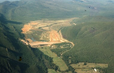
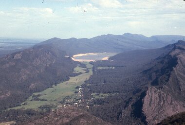
 Stawell Historical Society Inc
Slide, Ian McCann, Ariel View of the Construction of Lake Bellfield, 2022
... Ariel View looking up the Valley athte COnstruction of Lake... Ariel View looking up the Valley athte COnstruction of Lake ...Ariel View looking up the Valley athte COnstruction of Lake Bellfieldgrampians, lake bellfield -
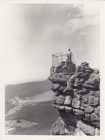 Halls Gap & Grampians Historical Society
Photograph - B/W, C 1960s
... that overlook a valley. A lake with a dam wall and rock tiers cut... that overlook a valley. A lake with a dam wall and rock tiers cut ...Photo is of 'The Pinnacle' lookout with Lake Bellfield in the background flanked by the Mt. William range. the photo is typical of 'tourism' photos taken by the Victorian Railways.Photo shows a man and a woman on top of a rocky outcrop that overlook a valley. A lake with a dam wall and rock tiers cut into the hillside can be seen as well as cleared areas some buildings. the lookout is enclosed with a wire fence.scenery, lookouts -
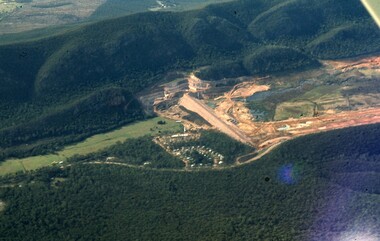
 Stawell Historical Society Inc
Photograph, Fyans Valley in Halls Gap -- Before lake Belfield was constructed
... Fyans Valley. Halls Gap. Before lake Belfield constructed.... grampians Photograph Fyans Valley in Halls Gap -- Before lake ...Fyans Valley. Halls Gap. Before lake Belfield constructed.stawell -
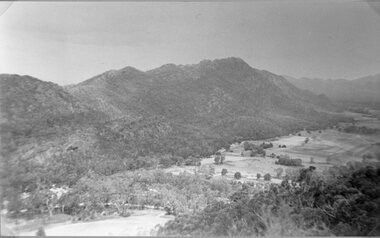
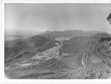 Halls Gap & Grampians Historical Society
Photograph - B/W
... of the valley and Lake Bellfield is the water at the end of the valley... the right edge of the valley and Lake Bellfield is the water ...Photo has been taken from Boroka Peak/lookout, of the Fyans Valley and the township of Halls Gap. The Grampians/Dunkeld Road can be seen running North/South along the right edge of the valley and Lake Bellfield is the water at the end of the valley. Photo is typical of those taken by Forrests Commission at the timea photo of a valley, mostly cleared, flanked by two mountain ranges. A large body of water can be seen at the far end of the valley (middle of photo). Buildings and roads visible in the valley. Plains can be seen beyond the far mountain range on the left side of the scene.no.42scenery, fyans valley -
Federation University Historical Collection
Book, A History of American Mining, 1932
... , Comstock Lode, Colorado, Mississippi Valley, Great Salt Lake, Black..., Colorado, Mississippi Valley, Great Salt Lake, Black Hills of South ...This book was presented to Charles Bacon by Seeley Wintersmith Mudd.Red hard covered book of 419 pages in the A.I.M.E. Series (American Institute of Mining and Metallurgical Engineering Inc). It includes a presentation Bookplate from Seeley Wintersmith Mudd made out to Charles Bacon. Chapters include mining in the far north, Comstock Lode, Colorado, Mississippi Valley, Great Salt Lake, Black Hills of South Dakota, Cooper of Lake Superior, copper in Arizona, Bunker Hill Enterprise, Butte The great Diamond Hoax, Flotation Process. The book includes some simple maps and plans. The book was dedicated to 'The most distinguished of American mining engineers Herbert Hoover'.t.a. rickard, herbert hoover, seeley wintersmith mudd, bookplate, charles bacon, mining, america -
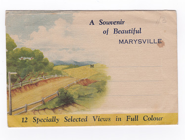 Marysville & District Historical Society
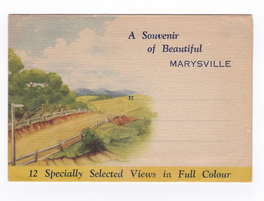
Postcard (item) - Colour photographs, Nucolorvue Productions, A Souvenir of Beautiful Marysville-12 Specially Selected Views in Full Colour, 1950's
... Cumberland Forest,/ Buxton, Narbethong, or the Taggerty Valley...,/ Buxton, Narbethong, or the Taggerty Valley. Skiers find Lake ...An envelope of 12 colour photographs of attractions in and around Marysville in Victoria.An envelope of 12 colour photographs of attractions in and around Marysville in Victoria. These photographs were produced by Nucolorvue Productions in Mentone, Victoria.A Souvenir of Beautiful MARYSVILLE 12 Specially Selected Views in Full Colour Marysville, Victoria, Australia Marysville, 60 miles from Melbourne, is one of nature's/ lovely beauty spots. The invigorating mountain air helps the/ visitor to enjoy the many delightful walks amongst the tall/ timber, or through the fern glades. Apart from many excellent walking trips, Marysville district/ offers ample scope for car trips to the nearby Cumberland Forest,/ Buxton, Narbethong, or the Taggerty Valley. Skiers find Lake Mountain an attraction in the winter, whilst/ the hiker finds ample for his needs in the numerous mountain/ areas. Huge Eucalypt trees, revealing their ramrod straightness up/ to 300 feet in height, are a fitting background to the many/ beautiful creeks and waterfalls. PUBLISHED BY NUCOLORVUE PRODUCTIONS, MENTONE, VICTORIA.nicholl's lookout (image 1), eildon weir (image 2), road to lake mountain (image 3), foot of steavenson falls (image 4), steavenson falls (image 5), bush scene near marysville (image 6), bush track marysville (image 7), bridge and chalet and crossways marysville (image 8), log cabin at marysville (image 9), black spur (image 10), taggerty river (image 11), highest known hardwood tree (image 12), marysville, victoria, nucolorvue productions, postcard, souvenir -
 Marysville & District Historical Society
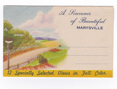
Postcard (item) - Colour photographs, Nucolorvue Productions, A Souvenir of Beautiful Marysville-12 Specially Selected Views in Full Colour, Unknown
... Cumberland Forest,/ Buxton, Narbethong, or the Taggerty Valley...,/ Buxton, Narbethong, or the Taggerty Valley. Skiers find Lake ...An envelope of 12 colour photographs of attractions in and around Marysville in Victoria.An envelope of 12 colour photographs of attractions in and around Marysville in Victoria. These photographs were produced by Nucolorvue Productions in Mentone, Victoria.A Souvenir of Beautiful MARYSVILLE 12 Specially Selected Views in Full Colour Marysville, Victoria, Australia Marysville, 60 miles from Melbourne, is one of nature's/ lovely beauty spots. The invigorating mountain air helps the/ visitor to enjoy the many delightful walks amongst the tall/ timber, or through the fern glades. Apart from many excellent walking trips, Marysville district/ offers ample scope for car trips to the nearby Cumberland Forest,/ Buxton, Narbethong, or the Taggerty Valley. Skiers find Lake Mountain an attraction in the winter, whilst/ the hiker finds ample for his needs in the numerous mountain/ areas. Huge Eucalypt trees, revealing their ramrod straightness up/ to 300 feet in height, are a fitting background to the many/ beautiful creeks and waterfalls. PUBLISHED BY NUCOLORVUE PRODUCTIONS, MENTONE, VICTORIA.nicholl's lookout (image 1), eildon weir (image 2), road to lake mountain (image 3), foot of steavenson falls (image 4), steavenson falls (image 5), bush scene near marysville (image 6), bush track marysville (image 7), bridge and chalet and crossways marysville (image 8), log cabin at marysville (image 9), black spur (image 10), taggerty river (image 11), highest known hardwood tree (image 12), marysville, victoria, nucolorvue productions, postcard, souvenir -
 Marysville & District Historical Society
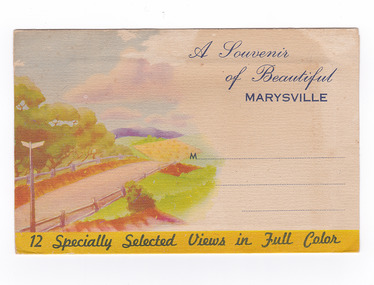
Postcard (item) - Colour photographs, Nucolorvue Productions, A Souvenir of Beautiful Marysville-12 Specially Selected Views in Full Colour, Unknown
... Cumberland Forest,/ Buxton, Narbethong, or the Taggerty Valley...,/ Buxton, Narbethong, or the Taggerty Valley. Skiers find Lake ...An envelope of 12 colour photographs of attractions in and around Marysville in Victoria.An envelope of 12 colour photographs of attractions in and around Marysville in Victoria. These photographs were produced by Nucolorvue Productions in Mentone, Victoria.A Souvenir of Beautiful MARYSVILLE 12 Specially Selected Views in Full Colour Marysville, Victoria, Australia Marysville, 60 miles from Melbourne, is one of nature's/ lovely beauty spots. The invigorating mountain air helps the/ visitor to enjoy the many delightful walks amongst the tall/ timber, or through the fern glades. Apart from many excellent walking trips, Marysville district/ offers ample scope for car trips to the nearby Cumberland Forest,/ Buxton, Narbethong, or the Taggerty Valley. Skiers find Lake Mountain an attraction in the winter, whilst/ the hiker finds ample for his needs in the numerous mountain/ areas. Huge Eucalypt trees, revealing their ramrod straightness up/ to 300 feet in height, are a fitting background to the many/ beautiful creeks and waterfalls. PUBLISHED BY NUCOLORVUE PRODUCTIONS, MENTONE, VICTORIA.nicholl's lookout (image 1), eildon weir (image 2), road to lake mountain (image 3), foot of steavenson falls (image 4), steavenson falls (image 5), bush scene near marysville (image 6), bush track marysville (image 7), bridge and chalet and crossways marysville (image 8), log cabin at marysville (image 9), black spur (image 10), taggerty river (image 11), highest known hardwood tree (image 12), marysville, victoria, nucolorvue productions, postcard, souvenir -
 Marysville & District Historical Society
Postcard (item) - Colour photographs, Nucolorvue Productions, A Souvenir of Beautiful Marysville-12 Specially Selected Views in Full Colour, Unknown
... Cumberland Forest,/ Buxton, Narbethong, or the Taggerty Valley...,/ Buxton, Narbethong, or the Taggerty Valley. Skiers find Lake ...An envelope of 12 colour photographs of attractions in and around Marysville in Victoria.An envelope of 12 colour photographs of attractions in and around Marysville in Victoria. These photographs were produced by Nucolorvue Productions in Mentone, Victoria.A Souvenir of Beautiful MARYSVILLE 12 Specially Selected Views in Full Colour Marysville, Victoria, Australia Marysville, 60 miles from Melbourne, is one of nature's/ lovely beauty spots. The invigorating mountain air helps the/ visitor to enjoy the many delightful walks amongst the tall/ timber, or through the fern glades. Apart from many excellent walking trips, Marysville district/ offers ample scope for car trips to the nearby Cumberland Forest,/ Buxton, Narbethong, or the Taggerty Valley. Skiers find Lake Mountain an attraction in the winter, whilst/ the hiker finds ample for his needs in the numerous mountain/ areas. Huge Eucalypt trees, revealing their ramrod straightness up/ to 300 feet in height, are a fitting background to the many/ beautiful creeks and waterfalls. PUBLISHED BY NUCOLORVUE PRODUCTIONS, MENTONE, VICTORIA.nicholl's lookout (image 1), eildon weir (image 2), road to lake mountain (image 3), foot of steavenson falls (image 4), steavenson falls (image 5), bush scene near marysville (image 6), bush track marysville (image 7), bridge and chalet and crossways marysville (image 8), log cabin at marysville (image 9), black spur (image 10), taggerty river (image 11), highest known hardwood tree (image 12), marysville, victoria, nucolorvue productions, postcard, souvenir -
 Greensborough Historical Society
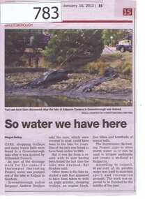
Newspaper clipping, Diamond Valley Leader, So water we have here, 16/01/2013
This article is about the recovery of stolen vehicles from the Kalparrin Lake after it was drained as a part of the Stormwater harvesting project. Other items recovered included a safe, shopping trolleys, an engine block, five bicycles and hundreds of tennis balls.The Stormwater will be used to water parklands and create a wetland at Kalparrin.A small newspaper article featuring a colour photograph.kalparrin reserve, stormwater harvesting, stolen cars -
 Greensborough Historical Society
Map, Melbourne and Metropolitan Board of Works. Survey Division, MMBW, Yarra 2500 / 12.24. Plenty and Blue Lake, 1977_10
... board of works shire of diamond valley plenty - maps blue lake ...Melbourne and Metropolitan Board of Works. Yarra 2500 [base map]. 12-24, Municipalities of Whittlesea 239 and Diamond Valley 257. Shows street names, easement sizes, lot numbers, lodged plan numbers, names of prominent features, contour values, creek or river names. Watsonia Railway Station and environs. Prominent streets: Memorial Drive. Includes Plenty River and Blue Lake in the Plenty Gorge.MMBW Map in 1:2500 [scale] series. Cream parchment with green tape reinforcing on edges and punched holes on left edge.mmbw, melbourne and metropolitan board of works, shire of diamond valley, plenty - maps, blue lake -
 Federation University Historical Collection
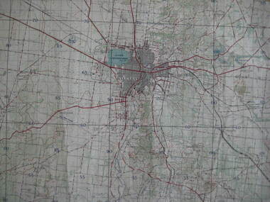
Map, Ballarat, 1936, 06/1936
... , Snake Valley, Linton, Newton, Durham Lead, Sebastopol, Lake... Ballarat, 1936 Map of Ballarat and surrounds, including Lake ...Map of Ballarat and surrounds, including Lake Learmonth, Snake Valley, Linton, Newton, Durham Lead, Sebastopol, Lake Wendouree, Winter Swamo. It was surveyed in 1933.ballarat, map -
Federation University Historical Collection
Document, Zelda Martin, Central Victorian Goldmining towns - Boom Towns or Ghost Towns?, c1996
Zelda Martin was a PhD candidate at the University of Melbourne.[.1] 4th item in light blue display book titled Research Approach/Overview of Chapters/Confirmation of Canditure/Chapters1,2,3&4 of proposed thesis. *Twenty-seven page article on Victorian goldfields towns titled: Central Victorian Goldmining Towns - Boom Towns or Ghost Towns. The article was written during the author's PhD study. It outlines the context methodology, and resources and the chapters of the proposed thesis: (1) Central Victorian Goldmining Towns - The Context (2) Contemporary Views of the Factors Necessary for Town Growth (3) Outward Manifestations of Town Growth (4) The Trappings of Government (5-9) The Main Towns and Their Hinterland. [.2] 5th item in Light Blue display book as above item. *Chapter 1 of proposed thesis titled 'Pick, Shovel and Tin Dish Mining.' Covers in Section A: Central Victoria - Pre 1851: Aborigines in Central Victoria, Squatters, and Government. Section B: The years 1851-1854: The Early Gold Rushes, Government Reaction, Township Surveys, Legislation, Town Development, Local Government and Early Settlement. [.3] 6th item in Light Blue display book as above item. *2A of proposed thesis titled 'Contemporary Views of the Factors Necessary for Town Growth'. Similar information to Chapter 1 plus extra re towns and maps. Sections: Introduction, Context of Place - Geographical Towns Listed, The Context of Time - Pre1851 Aborigines, Governance of Port Phillip, The Squatters, The Villages of Central Victorian Highlands, Conclusion, Condensed Version of Chapter2B. [.4] 7th item in Light Blue display book as above item. *Chapter2B of proposed thesis. Sections: Area of Research, Schools, Banks, Newspapers, Progress Association, Town Development - Sandhurst (Bendigo), Ballarat, Castlemaine,, Maryborough, Ararat and Stawell. [.5] 8th item in Light Blue display book as above item. *Chapter 3 of proposed thesis titled 'Outward Manifestations of Town Growth'. Sections: Introduction, Contemporary Writing, Educationalists, The Bankers, The Townsfolk, Current Theory, General Theories of Urban Development, and Conclusion. [.6] 9th item in Light Blue display book as above item. *Chapter 4 of proposed thesis titled 'Trappings of Government' Sections: Introduction, Early Government Attitudes to Mining and Town Development, Law and Order, Township Surveys, Legislation, Local Government, Transport and Communication, The People and Lobbyists. [.7] 10th item in Light Blue display book as above item. *'The Rise and Fall of Central Victorian Goldmining Towns'. Includes a map showing main Goldfields, a table showing towns and villages at two points in time - 1857 and 1871; a Bibliography of Primary and Secondary Sources. [.8] Resource No1. Black display book titled Local Towns 1 : Alma: *Brief history *Directory *Maps Amphitheatre / Mountain Hut: *Brief History Post Office Directory Ararat: *Brief History *Post Office Directory 1869 - Alphabetical Listing by Occupation *Ararat - Prominent Citizens of 1858 *Langi-Morgala Museum Avoca: *Brief History *Excerpts from 'Avoca The Early Years', Margery and Betty Beavis; pg1 - Beginnings; pg11 - The Midas Touch; pg25 - Local Gold Escorts; pg27 - A Town is Born; pg51- The Administration of Justice; pg53 - The Ways of the Law; pg61 - News of the Day; pg65 - A Time to Play; pg72 - Land Ownership *Post Office Directory (Bailliere's) 1869 *Tourism Map and Information of area *Historic Avoca - A 5.5km Tour *Avoca & the Pyrenees Region - information pamphlet Ballarat: *Early History of Ballarat - Ballarat Historical Society, Publication No.1: origin of the name; Ballaarat - the Beginning; Fabulous Yields from the Ballaarat Goldfield; *Streetscape Lydiard Street. *Hand drawn map showing Leigh River, Old Portland Bay Road, plaque on road to Colac; etc. *Newspaper article re 'The Theatre Royal' ( which stood in the vicinity of the current Owen Williams store) - 'The News'15/04/1998 *Article - 'Ballarat's Mechanics' Institute Lives On' Ballarat Courier, 14/09/1985 *Article - Standing the Test of Time' The News 17/11/1993 re The Mechanics Institute & picture of the Reading Room *'Ballarat a Study of a City, Phyllis Reichl, pub. Nelson, 1968; no.3 place, time and people field studies series *Investigator Vol.33 No.2, 1998 Geelong Historical Society. Article on pg75 describes Ballarat in 1861 *Folded poster - 'Ballarat 100' a history of telegraph communication, pub. Telecom. Beaufort (Fiery Creek): *Brief history *Post Office Directory [.9] Resource No.2 Black Folder Titled Towns cont.No2 Bendigo (Sandhurst): *'Family & Local History at the Bendigo Library - 1851-2001 150 years of gold'. *Bendigo Government Camp in 1853 illustration; key to sketch and names of Government officers stationed there *Excerpts from 'Bendigo and Vicinity' Adolph Haman *The Bendigo Goldfield Registry - pgs 1-7 Introduction *Excerpt: 'Breaking the Grip' *Excerpt: The Most Go-Ahead Place *Excerpts from 'History of Bendigo' - anti license agitation; laying out of town; proposed railway; gold calls and dividends; the Sandhurst Municipality; journalism *Bibliography Blackwood: *Excerpts from 'Aspects of Early Blackwood - The Goldfield, the Landmarks, the Pioneers' Alan J Buckingham and Margaret F Hitchcock, JG Publishing,1980 Buninyong: *A Brief History *Investigator Vol1 No.2 Feb 1966 Geelong Historical Society. Pg3 - Article re gold escort route - Mt Alexander to Adelaide - (see a simple monument on the Western Highway a few miles out of Horsham. Pg 15 - Ballarat Excursion - re the finding of gold. *Three articles published by Buninyong and District Historical Society Inc: (Magpie Exploration; Finding Gold In The Green Hills; Magpie Exploration; Burnt Bridge to Cargarie to Mt Mercer) *Copies of newspaper articles/items *Buninyong Street Directory Carisbrook: *In the Beginning There Was Carisbrook *The History of the Carisbrook Racecourse Carngham / Snake Valley: *Brief History *Directory Castlemaine: *Directory 1865-1866 - Alphabetical and Street *Poster - Castlemaine A Contemporary Guide "The Great Centre" 1866 - A Contemporary Guide to the Fascinating Past *Pamphlet - Castlemaine District Community Hospital *Map - Castlemaine, Maldon & Surrounding Districts *Map and Information - The Dry Diggings Track - a 55kl walk among historic goldfields relics ( Castlemaine Fryerstown Vaughan Mt Franklin Hepburn Daylesford) *Postcard - Former Court House *Directory 1867 - Alphabetical, Trade [.10] Resource No.3 Grey folder Titled Towns 3 Creswick to Maryborough Creswick: *Brief History *Booklet - "Creswick Cemetery Walk" *Booklet - The Buried Rivers of Gold Heritage Trail Creswick *Creswick Historical Museum Information Sheet *Chronological History of Creswick *Alphabetical Directory of the Borough of Creswick *Creswick's Creek Directory 1856 *Historic Creswick Walking Tour *A Brief Account of the Schools of Creswick - Past and Present *100 Years of Railway Travel in Creswick *The Berry Deep Leads *The Spence Home at Jackass Gully in the Creswick State Forest ( William Guthrie Spence - Pioneer) *The New Australian Mine and the 1882 Disaster *Creswick District News, Issue 7, July August 1999 *The Creswick Miners Walk - Information and Map *Maps Chewton: *Brief History *Directory Clunes: *Brief History *Clunes Street Directory Daylesford: *Brief History *Notable Bushfires in Daylesford District Over More Than a Century - "Black Thursday" 1851; 1862; 1899; the Disastrous Hepburn Fire of 1906; 1939; 1944; 1969. *Post Office Directory -Daylesford and Hepburn Dunolly / Inkerman: *Brief History *Directory *Pamphlet - Goldfields Historical Museum *Pamphlet - Historic Dunolly - Victoria's Best Kept Secret *Map of Gold Workings at Dunolly Area - showing where the main gold rushes occurred *Brief History - Inglewood *Directory - Inglewood - Name Occupation, Dwelling Kingower: *Brief History *Directory - Name / Ocupation / Dwelling Linton / Happy Valley / Piggoreet: *Brief History *Directory - Lintons McIvor: *"A History of the Shire and the Township of Heathcote" by J.O. Randell Majorca: *Brief History *Official Post Office Directory 1869 - Name / Occupation/ Address Maldon (Tarrangower): *Brief History Part 1 *Brief History Part 2 *Post Office Directory *List - Alphabetical Order by Names plus Business and Trade (Tarrangower Times Oct/1858) *List - Alphabetical Order by Trade plus Name and Business *Directory - Name / Occupation / Dwelling Maryborough: *Worsley Cottage - built by Arthur Worsley, a contractor in stonework in 1894 [.11] Resource No. 4 Blue Display Book titled Towns 4 Moliagul to Stawell Moliagul: *Brief History *Moligul Legislative Assembly (Voting?) List - Names and Occupations *Moliagul Victorian Post Office Directory 1868 - Name / Ocupation / Address / Comments *"The Welcome Stranger" gold nugget *The Sunday School *The Welcome Stranger Discovery Walk - information and map Moonambel (Mountain Creek) Redbank *Brief History *List of names extracted from advertisments of the Pioneer and Mountain Creek Advertiser 16/02/1861. *Bailliere's Directory 1869 - Alphabetical List of Name / Occupation / Place St Arnaud: *Brief History Sebastapol: *Brief History *Directory 1869 - Alphabetical by Name; plus occupation and address. Browns and Scarsdale: *Brief History *Browns Street Directory - Name and Occupation Smythesdale: *Brief Description *Smythesdale Street Directory -Name and Occupation Stawell (Pleasant Creek) *Brief History *Victorian Official Post Office Directory - Name /Occupation / Dwelling *Chronology - 1841-1920 *Production of gold statistics - 1879 - 1900 *Big Hill *Extracts from "The Golden Years of Stawell". Chapt 1 - Stawell's Coming Out. Capt. 2 - The Gold Rush. Caapt.3 - Cradle of Democracy. Chapt.4 - The Reefs Becomes Stawell. Chapt. 5 - Rushing In. Chapt.6 - The Pioneers. Chapt 7 - The Decade of Optimism. [.12] Resource No. 5: Blue Display Book titled 'Towns Steiglitz to the The Golden Triangle. Steiglitz: Brief History Victorian Post Office Directory 1869 *Map of Steiglitz *List of maps relevant to Steiglitz history *Information 6 tables of data from "Reports of Mining Surveyors Talbot (Back Creek) Brief History Taradale: Post office Directory 1869 - Name/Occupation/Street. Also list in alphabetical order by Occupation Taradale *Chronological Reference to Taradale Mines *Water - The Coliban System of Waterworks *Joseph Brady *The Syphon Tarnagulla (Sandy Creek) *Brief History *Tarnagulla Businessmen Cameos to give depth to advertisments in 'The Tarnagulla Courier' various issues 1864-1871 *Directory - Name/Occupation /Address *List - Name/Business/Trade Wedderburn (Koorong) *Brief History *List - Name/Occupation The Golden Triangle: *The Early Rushes - Wedderburn / Moliagul / Sandy Creek - Tarnagulla / Jones Creek - Waanyarra / Kingower / Dunolly - Goldsborough / Inglweood *Census of 1857 - Population / Occupations *1858-1871 - A Time of Consolidation- Wedderburn / Moliagul / Sandy Creek- Tarnagulla / Arnold *Census 1871 - Population *Information gleaned from the census data - Demographics / Population / Occupations / marital / Birthplace / Religion / Literacy/ Occupation and Housing Cameos *Graphs - Birthplace of settlers /Male-Female Ratio / Married males / Children under 15 as Percentage of Population / Religion *Census 1857 - Statistical data *Maps *Bibliography [.13] Resource No. 6 - Black Display Book Information and Research in Central Victoria including: *Banking - Research from ANZ Bank Archives *Institutions - also includes articles listed from the Ballarat Times Newspaper *Australian mining History Association - A.M.H.A. Bibliography *Australia's Mining History * Bibliography - Land Surveys Victoria - *1853 Administration (Statistics and Other) includes: schools / ministers of religion / police / military / local administration / licences for sale of spirits / distances between various Victorian gold fields. * Victoria Government Gazette (Copy) - N0. 116, 12/12/1854 includes: Gold Felds Commission of Enquiry & No. 85, 15/09/1854 - Addresses presented to the Lieutenant Governor (Sir Charles Hotham) during his tour through the Gold Fields of Victoria,1854. Addresses on behalf of : the people of Bendigo; Members of the Church of England, Bendigo; Members of the Wesleyan Church on the Bendigo Gold Fields; Bendigo Gold District General Hospital; the Bendigo Prospecting Association; Committee of the Bendigo Local Exhibition; Bendigo District Medical Association; Coloured Americans Resident at Bendigo; German Inhabitants of Bendigo; Landowners, Inhabitants, and Miners of Castlemaine; Inhabitants of Forest Creek; Inhabitants of Heathcote and Gold Miners of McIvor; Residents and landholders of the District of Bacchus Marsh; Inhabitants of Kilmore and Vicinity. *Gold Fields Correspondence 1853: letter from Lieutenant Colonel Valiant, (Officer commanding the Troops in Victoria) to the Lieutenant Governor re threatened disturbance at Sandhurst (Bendigo) regarding the Gold License Fee. * Extracts from a book "Victoria" re Gold Fields Commission of Enquiry involving mainly Ballarat and Castlemaine and a chapter titled 'A Tour to the Victorian Gold-Fields' *Lists of central Victorian newspapers - listed by date published 1851to 1874; by first date available to State Library. *A list of cities and towns showing County, population in 1861 &1871, and municipal status. [.14] Resource no.7. Black display book. *Reference: Papers presented to Parliament Victoria - 1859-1860 4 volumes - relevant sections copied. Contains information on Branches of Government. General / Finance / Gold / Gazette / Commission and Warrant / Statistic. *Gold Fields Act. In accordance with the Act the gold fields are divided into six districts - Ballaarat, Castlemaine , Sandhurst, Avoca, Ararat, and Beechworth.. Official staff in each gold district consists of a Resident Warden, Wardens, Wardens' Clerks, Bailiffs, Chinese Protectors, Chinese Interpreters, and Mining Surveyors. *Gold Receiver *Gaols *Police magistrates and Clerks of Petty Sessions, etc. *Field Branch *Immigration and Emigration Overland - Chinese - 1859 *Population on the Goldfields *The Geological Survey - The Government Geologist is assisited by staff from four branches - the office Branch; the Publishing Branch; the Field Branch and the Museum Branch. *Commission to Enquire Into Sludge dated 10/02/1859 (Some sections copied) - Report to the Honorable Chief Commissioner of Public Works, Melbourne re the mode of carrying the sludge from the puddling mills in Sandhurst without interfering with the drainage of the town and the roads in the neighbourhood. [.15] Resource No.8: Camel display book titled Resource No. 8. Aborigines *Lists of book titles - +"Readings in Victorian prehistory" +"The Aborigines of Port Phillip" +Aboriginal languages and clans" +"A History of the Port Phillip District" +"Langi Ghiran 1: Aboriginal Rock...." +"Koorie History: sources for aboriginal studies in the State Library of Victoria", ed. Tom Griffiths, Melb. Friends of the State Library, 1989 +"The Public Lands of Australia Felix"; settlement and land appraisal in Victoria1834-91 with special reference to the Western Plains", J.M.Powell, Melb. Oxford University Press 1970 +*Bibliography of the Victorian Aborigines' from the earliest manuscripts to 31st December 1970, Massoa, Aldo, Melb. Hawthorn Press, 1971 +"Aborigines in Colonial Victoria, 1836-1886", M.F. Christie, Sydney University Press, 1979 +"Urban and Industrial Australia: readings in Human Geography" ed J.M. Powell, Melb. Sorrett Pub. 1974 *Extracts: -Processes of Pioneer Settlement - The Squatting Occupation of Victoria, 1834-60. J.M. Powell -Areal Variations in the Class Structure of the Central-Place Hierarchy. P. Scott - Volume1 and Volume 2: Notes Relating to the Habits of the Natives of Other Parts of Australia and Tasmania. Compiled from various sources for the Government of Victoria by R Brough Smyth. John Curry, O'Neil, Melb. 1st pub. Melb. 1876. p31-45 - Numbers and Distribution of the Aborigines in Victoria -Victorian Aborigines 1835-1901 - A Resource Guide to the Holdings of the Public Record Office, Victoria; published by the Government Information Centre 1984. *History of the Aboriginal Artefacts Displayed in the Daylesford Museum. F. G. Powell (4 page pamphlet) *Letter to Zelda Martin from Peter Lovett, Cultural Officer, Ballarat & District Aboriginal Co- Operative, 05/02/1997 *Map: Ian Clarke Victorian Tribunal Boundary Map - Clans of Central Victoria. *Victorian Rock Art and Mythology - Article about Mount Langhi Ghiran and myths of the Tjapwarong people. *Two Aboriginal myths relating to the Grampians - 'The Monster Emu' / 'The Aquisition of Fire', by the Aborigines in the Grampians Areas *Article titled (chapter 8) Ballarat - information re camping sites in the region. Lake Wendouree / Lake Burrumbeet (includes a myth) / Mt Bunninyong / Lal Lal / Pitfield / Mount Elephant / Mount Egerton / Meredith / Lake Goldsmith / Lake Learmonth / Ercildoune *Notes on the Aborigines of the Wider Ballarat Region plus European names=Aboriginal names. John Morris 26/07/1995 *Role of Aborigines in Town Development in Central Victoria. Mentions Native Police Force est. in Port Phillip 1842 and Central Board for Aborigines est. 1860 *The Grave of King Billy. (Frank Wilson) Pamphlet. *Camping Places in Central and Northern Victoria. Article re Lake Burrumbeet site. *Programme for the Unveiling of Memorial Cairn for Edward Stone Parker 1802-1865. Note portrait not accurate. Accurate portrait is available in the book "A Successful Failure A Trilogy The Aborigines and Early Settlers", Edgar Morrison, Graffiti Publications, 2002. * Large envelope addressed to Mr G Netherway containing newspaper cuttings regarding the life of Edward Stone Parker, the unveiling of the Memorial Cairn as mentioned above, articles titled 'Episodes from Our Early Days' (Edgar Morrison, Yandoit)- The Black's School, A School At Last and The Final years. Also a typed page titled 'Historical Background to E.S.Parker's Career. Includes an interesting tale titled 'When the cat lay doggo' re laying power leads for the unveiling ceremony at the memorial site. [.16] green display folder titled 'Research Aids' *List of references to Commissioners' & W'ardens' Reports (formerly held at La Trobe Library Archives, now at Public Records Office [PRO]). Indicates town referred to / date of report / name of camp if different to town. * Archive information re Anglican Records *Movement around the Goldfields - Miners and Storekeepers - usefulness of newspapers in providing information - areas covered - Castlemaine, Maldon, Ararat, Stawell, Tarnagulla, Dunolly. *Port Phillip /Victoria Directories 1839/1867 - Chronological list of Directories included in this series. *"Notes on the History of Local Government in Victoria" A.W. Greig Melb. University Press 1925 - Photo-copied extract p5-p40. (Source - Deakin University Library) - Introduction by W.Harrison Moore. Section 1 - Development in New South Wales Before Separation. Section 2 - Development in Victoria After Its Separation from New South Wales. Hand written notations: 'roads, markets, and local government 1855 on' ;'opportunity of squatters in parliament' and 'opportunities of matters in parliament p33' * Notes on the Establishment of Surveyor General's Department 1851and Commissioner of Crown Lands and Survey. * Newspaper articles from The Argus, 1849, re the discovery of gold in the Pyrenees region. * Excerpt - a report on schools - A.B.Orlebar, Inspector; re the need for permanent school buildings rather than tents. *Excerpt from - 'Approaches to Urban History', Sean Glynn: The Case for Caution * Except from - 'The Urban Sprinkle', Weston Bate: Country Towns and Australian Regional History *Reference- 'The History of Land Tenure in the Colony of Victoria', John Quick. References the Haines Land Bill, land tenure and Land Leagues. [.17] Light blue envelope folder titled 'Birtchnell's Ballarat, etc. Directory 1862 *Contains various directories for Smythesdale, Buninyong, Clunes, Brown's and Creswick. [.18] Red envelope folder no.2 titled Victorian Gazetteer *Selected pages from 1869 Victorian Gazetteer on A4 paper (with a handwritten note questioning if some pages are from 1868 Victorian Gazetteer as appears to be different sizes - A3 pages.) Information includes locations and descriptions of towns, hotels, banks, communications and populations. (Does not include names, residences and occupations) [.19] Red Envelope folder titled Bailliere's Official Post Office Directory 1868 (or1869 or a mixture of both?) *Preface *Contains a selection of pages of towns highlighted in yellow in the the index *Work on this directory was commenced in 1867. *Information includes: Municipalities - mayors and councilors; lists of towns naming male inhabitants and their occupations. [.20]Yellow manila folder titled Post Grad Seminar Presentation 1996 *Gives some background to Zelda Martin's proposed thesis and why she chose the topic Gold Mining Towns Boom or Bust [.21] A3 display book - No. 1A * A list of 'Relevant Newspapers collected: The Tarrangower Times and Maldon Advertiser (first published 1858) Includes dates 1858-1867. The Mount Alexander Mail. Includes dates 1854-1866 The Tarnagulla Courier. Includes dates from1864-1871 Dunolly and Burnt Creek Express. Includes dates from 1862-1871 * Selection of newspaper pages from The Mount Alexander Mail 1854 to 1856, mostly showing advertisements for businesses and services provided to that community. [.22] A3 display book - No. 1B * Selection of newspaper pages from The Mount Alexander Mail 1857 to 1866, mostly showing advertisements for businesses and services provided to that community. [.23] A3 display book -No. 2 * Selection of newspaper pages from The Tarnagulla Courier 1864 to 1871, mostly showing advertisements for businesses and services provided to that community. [.24] A3 display book - No. 3 *Selection of newspaper pages from The Tarrangower Times (and Maldon and Newstead) Advertiser 1858 to1867, mostly showing advertisements for businesses and services provided to that community. [.25] A3 display book - No.4 * Selection of newspaper pages from The Dunolly and Burnt Creek Express; and The Dunolly and Betbetshire Express 1862 to 1871, mostly showing advertisements for businesses and services provided for that community. [.26] A3 display book - No.5 Includes: * Bryce Ross's Diggings Directory. Includes instructions for using this directory. This directory was used by "all persons having connexion or desiring to communicate with 'working parties, private friends, or Stores at the Diggings." As a directory for each area wwas completed it was published in each month's issue of Bonwick's "Digger's Magazine." Years c1852/1853. This Directory commences first at the head of Forest Creek. Includes a directory for Bendigo and Ballarat. Of interest at the end of the Bendigo and Ballarat directory is a list of the number of storekeepers, butchers, doctors, smiths, eating houses, lemonade sellers and chapels. * The Castlemaine Directory and Book of General Information Comprehending Glass's Model Calendar for the Two Years 1862 and1863. "zelda martin, victorian goldfield towns, bendigo, castlemaine, ballarat, maldon, stawell, ararat, maryborough, creswick, avoca, heathcote, banks, bank of australasia, union bank of australia, government camp, sandhurst, water supply, tarnagulla, talbot, back creek, mountain creek, police court, carisbrook, dunolly, thompson's foundry, charles clacy, anthony trollope, robert cecil, mount alexander, urbanisation, national schools, education, govenrment, industry, railway, transport, settlement, land settlement in central victoria, steiglitz, joseph brady, the new australian mine, berry deep leads, william guthrie spence, creswick state forest, arthur worsley, worsley cottage, the welcome stranger, moliagul, moonambel, redbank, st arnaud, sebastapol, brown's, scarsdale, clunes, chewton, daylesford, bushfires, inkerman, inglewood, kingower, lintons, happy valley, piggoreet, mcivor, majorca, tarrangower, taradale, the coliban system, the syphon, sandy creek, wedderburn, koorong, arnold, jones creek, waanyarra, the golden triangle, census 1857, blackwood, buninyong, durham lead, magpie, carngham, snake valley, alma, amherst, daisy hill, amphitheatre, mountain hut, beaufort, fiery creek, counties, population, gold fields commission of enquiry1854, william westgarth, gold license fee, lieutenant colonel valiant, administration of the victorian gold fields, commission to enquire into sludge 1859, e.s. parker, edward stone parker, edgar morrison, mount franklin protectorate, dja dja wurrung, memorial cairn, franklinford, mt franklin memorial cairn, jajowurrong, dja dja wurung, tjaowarong, wothowurong, assistant protectors, daylesford museum, buluk, rock art - grampians, aboriginal mythology - grampians, aborigines, first nations people, mount franklin, aboriginal artifacts, lake burrumbeet, native police force, central board of aborigines, yandoit, commissioners' reports, wardens' reports, port phillip/victoria directories 1839-1867, local government - victoria 1853/1854, surveyor general's department - 1850's, victorian schools 1850's, a.b.orlebar, haines land bill, william charles haines, wilson gray, land tenure, land leagues, victorian gazetteer, the tarrangower times and maldon advertiser - 1858-1867, the mount alexander mail 1854-1866, the tarnagulla courier 1864, dunolly and burnt creek express 1862-1871, bryce rose's diggings directory, the castlemaine directory 1862-1863 -
 Federation University Historical Collection
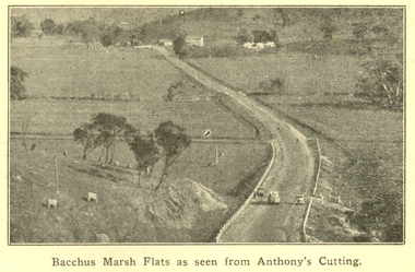
Booklet, F.C. Mc C. Crisp, Bacchus Marsh Centenary Celebrations, 10/1936
Bacchus Marsh celebrated 100 years of white settlement in 1936. The centenary celebrations committee comprised of L.M. Dugdale (President), A.W. Bond (Hon. Secretary), Charles Dickie, W. Grant Morton, W.R. Vigor, C.J. McFarlane, G.H. Anderson, T.J. Shea, F.C. McC Crisp, Dr E. McDonald, Robert Elliott (treasurer), R.H. Lambert (Decorations manager)Brown covered book of 28 pages. The book includes an historical essay, official centenary programme, Electric Light Plant, Patriotic Bacchus Marsh, milk industry, Pioneer Women's Memorial Avenue, Bacchus Marsh Gas Works . The book includes numerous advertisement, some illustrated. Images include: * Bacchus Marsh Flats from Anthony's Cutting; * Manor house; * Scene in Maddingley Park * Werribee Valley; * Werribee Gorge * Maddingley Park lake; * ANA Hall and Post Office * Shire Hall and Soldiers' Memorial Hall, * State School No 28 * At Werribee Gorge ** The Gas Supply Co, Bacchus Marsh * Bacchus Marsh Shire Council, 1935-6 (named) Images depicted in the book were supplied by H.J.M. Vallancebacchus marsh, merrimu guest house, anthony's cutting, captain bacchus, manor house, maddingley, maddingley park, werribee gorge, bacchus marsh shire, bacchus marsh shire council -
 Federation University Historical Collection
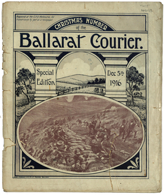
Magazine - Photograph - Black and White, Berry, Anderson & Co, Ballarat Courier Special Christmas Edition, 1916
A magazine supplement of the Ballarat Courier containing articles, images and advertisement. Images include: St Patrick's Day March, Eight Hour Day procession Advertisements include: Morris undertaker, Olivers, Miller, Hanrahan's Hotelst patrick's day, ballarat townscape, st patrick's day parade, ballarat st patrick's day parade, ballarat courier, hanrahan, morris, labour day, 8 hour day, eight hours day procession, st patrick's day procession, mrs captain ellis, picture palace, grenville college, berry united company ullina, lewis s. smith architect, bolster brothers, buninyong butter factory, aquatic carnival, george e. deeble machinery, cape nelson portland, jelbarts, jelbart's telescope, lin hillman, presbyterian church snake valley, miss a.m. abrams, berry anderson and co, j.a. reynolds, maypole, w.f. coltman, ballarat boot palace, ben nevis elmhurst, jonathan reeve, victorian producers co-operative, r.u. nicholls, f.w. barnes and son, ballarat steam laundryballarat water reserves, yarra river warburton, erskine river lorne, john bray, eden studios, lake wendouree -
 Federation University Historical Collection
Book, Final recommendations Ballarat Study Area Land Conservation Council, Victoria, 1982
Yellow soft covered report of 95 pages . The contents of the report include: Parks, reference areas, wildlife reserves, water production, harwood production, softwood production, flora Reserves and Flora and Fauna reserves, bushland reserves, historic area and reserves, rivers and streams, Roadside conservation and Highway parks, Education areas and School Plantations, Lake Reserves, geological reserves, recreation, scenic reserves, agriculture, mineral and stone production, utilities and survey, township land, Uncommitted Land, military training, other reserves and public land. Maps include: The Study area 1: 250 000 Supplementary Mapsland conservation authority, ballarat, endowment plantations, pine plantations, langi ghiran state park, mount buangor state park, enfield state park, ballarat-creswick regional park, rossbridge, black lake, flax mill swamp, dereel lagoon, lake bolac, lake wongan, langi ghiran reservoir, gong gong reservoir, pincotts reservoir, beales reservoir, wilsons reservoir, moorabool reservoir, korweinguboora, korweinguborra reservoir, learmonth bores, sago hill, illabarook reservoir, ballarat water commission, dunneworthy, mount cole, mont lonarch, ben major, waterloo, trawalla, linton, ross creek, canadian, shepherds flat, lal lal, mount doran, raglan, chute, carngham, buninyong, watsons hill, enfield, cape clear, illabrook, rokewood junction, mount warrenheip, nerrina, jubilee, golden stream, australasian deep lead mine, happy valley school, piggoreet, berringa, bulldog, ballarat common, wildlife, water, timber, flora, rivers, geology, agriculture, warrenheip -
 Federation University Historical Collection
Book - Scrapbooks, William RObertson, Newsclips written by William Robertson, c1930-c1948
Small brown covered scrapbook with newsclipping written by William Robertson, and his handwritten corrections to the articles. Newsclips include poetry and articles on: Piggoreet, Captain Moonlight, Devil's Kitchen, Ballarat East Australian Natives' Association, A Total Eclipse, Ballarat Leads, Joe Mack Cricket, Trade Unionism, Jack Hewitt of Piggoreet, Astronomy, Golden Lake, Scientific Shearers, Eureka, Piggoreet Geological, Piggoreet Mining, Happy Valley, Exchequer Flat, Fairy's Fright, H.V. Mailboy, Shearers, Creswick, Geology of Smythesdale, Shearing in the 1890s, Piggoreet reunion, Scarsdale and Smythesdale, Scarsdale to Golden Lake, Derwent Jacks, Shanties Devil's Kitchen, Berringa Bushmen, Perseus, Kruger at Pitfield, Fires and Pitfield, Football Memories, Cambrian Hill, Theo Gribble, Jack Jones Pitfield, Risks at Pitfield, Superstition, Scarsdale, death notice for William Robertson's mother.On cover: "Wm Robertson 10 Young Street Ballarat East"andrew christie, mrs nimon, william christie, alec christie, grand trunk, cape clear, donald mclean's, alchemist co, john lynch, golden belt lead, paddy webb, annie rooney, kruger hanging, pitfield, boer war, napoleons, cambran hill, hiscocks, john winter, john jenkins, bonshaw, john bird, nintingbool, moppianum station, w.h. bird, david clarke, william hamilton, john clarke, benjamin j. scott, julius kleberger, m.a. weatherston, j.h. vaughan, a. reid, alfred william crow, p. young, george clarkson, a.w. crowe, william henderson, claud pender, a. garside, mount erip, alec crothers, communism, basalt, italian gully, john roberts, john browne, john crossthwaite, patrick mcgrath, newtown, john boyd, john bruce, william irwin, george hatfield, d. croswaite, grand trunk mine, golden horn, jubilee lode, woady yallock, springdallah, fairy glen lead, linton lead, south berry, banshee, wil-o-the wisps, forest creek, chewton, mount alexander, jim crow ranges, trawalla, j.g. roberts, carngham, german lead, scarsdale railway, great western, beaumont mine, north grenville, shearing, piggoreet reunion, scarsdale and smythesdale, scarsdale to golden lake, derwent jacks, shanties, devil's kitchen, berringa bushmen, perseus, kruger at pitfield, fires and pitfield, football memories, cambrian hill, theo gribble, jack jones pitfield, risks at pitfield, superstition, scarsdale, golden point lead outlet, frenchman's lead, trooper o'brogue, peroni, morelli, lucky woman's gully, william robertson, piggoreet, captain moonlight, devil's kitchen, ballarat east australian natives' association, total eclipse, ballarat leads, joe mack cricket, trade unionism, jack hewitt of piggoreet, astronomy, golden lake, scientific shearers, eureka, piggoreet geological, piggoreet mining, happy valley, exchequer flat, fairy's fright, h.v. mailboy, shearers, creswick, geology of smythesdale -
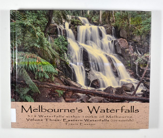 Marysville & District Historical Society
Book - Hardcover book, Travis Easton, Waterfalls of Victoria-Volume Three-Eastern Waterfalls, 2015
A book of photographs and information pertaining to the waterfalls in Eastern Victoria.A book of photographs and information pertaining to the waterfalls in Eastern Victoria.Hardcover. Front cover has a photograph of Toorongo Falls and back cover has a photograph of Evelyn Falls with a synopsis of the book.Gift fo Marysville & District Historical Society by Travis. 17 After catching up with my family because I had lingered to take a few more photographs,/ I was serenaded with the following song:/ Don't go chasing waterfalls/ Please stick to the rivers and the lakes that you're used to/ I know that you're gonna have it your way or nothing at all/ but I think you're moving too fast/ from the song Waterfalls by TLC Dedicated to my wife and children: Monique, Iona, Zahra, Jasmine & Flynn,/ who have continued to love me despite my waterfall chasing ways.waterfalls, eastern victoria, travis easton, photographs -
 Marysville & District Historical Society
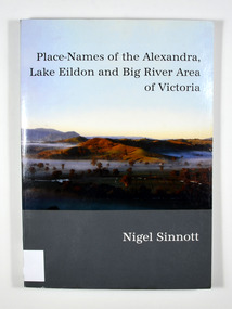
Book, Place-Names of the Alexandra, Lake Eildon and Big River Area of Victoria, 2003
Place names of the Alexandra, Lake Eildon and Big River areas in VictoriaPaperback. Front cover has a colour photograph named: 'Sunrise, Brooks Cutting near Alexandra', by Robert Douglas (2002). Back cover has a colour photograph of the author, Nigel Sinnott at McKenzie's Pinch, Alexandra (Mount Torbreck in background) by Robert Douglas (2002).To George Edwards / with best wishes, / Nigel Sinnott / 15 March 2003 To the memory of / Gordon BEATON (1911-88) / of Eildon / mycologist and engineer Stamp of Marysville & District / Historical Society Inc / P.O. Box 22 / Marysville 3779 geographical, victoria, big river region, eildon region, alexandra region, alexandra library, friends -
 Marysville & District Historical Society
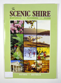
Book, The Scenic Shire-Marysville-Alexandra-Eildon, 1987
A book outlining recreational activities available in the towns of Marysville, Alexandra and Eildon and their surrounds Paperback. Front cover has a series of colour photographs depicting flora, places to visit and activities in the areas named in the title. Back cover has a photograph of houseboats at Eildon Boat Club at Anderson Harbour on Lake Eildon.Stamp of Marysville & District / Historical Society Inc / P.O. Box 22 / Marysville 3779marysville, alexandra, eildon, recreation -
 Marysville & District Historical Society
Book, The Scenic Shire-Marysville-Alexandra-Eildon, 1987
A book outlining recreational activities available in the towns of Marysville, Alexandra and Eildon and their surrounds Paperback. Front cover has a series of colour photographs depicting flora, places to visit and activities in the areas named in the title. Back cover has a photograph of houseboats at Eildon Boat Club at Anderson Harbour on Lake Eildon.Stamp of Marysville & District / Historical Society Inc / P.O. Box 22 / Marysville 3779marysville, alexandra, eildon, recreation -
Marysville & District Historical Society
Flyer (item) - Brochure, Artworkz Tourism, Marysville-Steavenson Falls, 2018
A brochure including photographs and a tourist map of Marysville and some of the area's attractions focusing on Steavenson Falls. A brochure including photographs and a tourist map of Marysville and some of the area's attractions focusing on Steavenson Falls. The Steavenson Falls is named after the Victorian Assistant Commissioner of Roads and Bridges, John Steavenson who arrived in Victoria in the early 1860s.Shadowed by over 30 Mountains and/ on the banks of the beautiful Goulburn River/ and Lake Eildon. This is our playground.marysville, steavenson falls, victoria, waterfalls, john steavenson